Iguazu Falls map: how the area is laid out
The falls lie where the Iguazú River forms the border between Argentina and Brazil. Each country runs its own national park, with its own entrance, tickets and trails. Puerto Iguazú is the Argentine town. Foz do Iguaçu is the Brazilian city. Paraguay is a short distance away at the tri-border point.
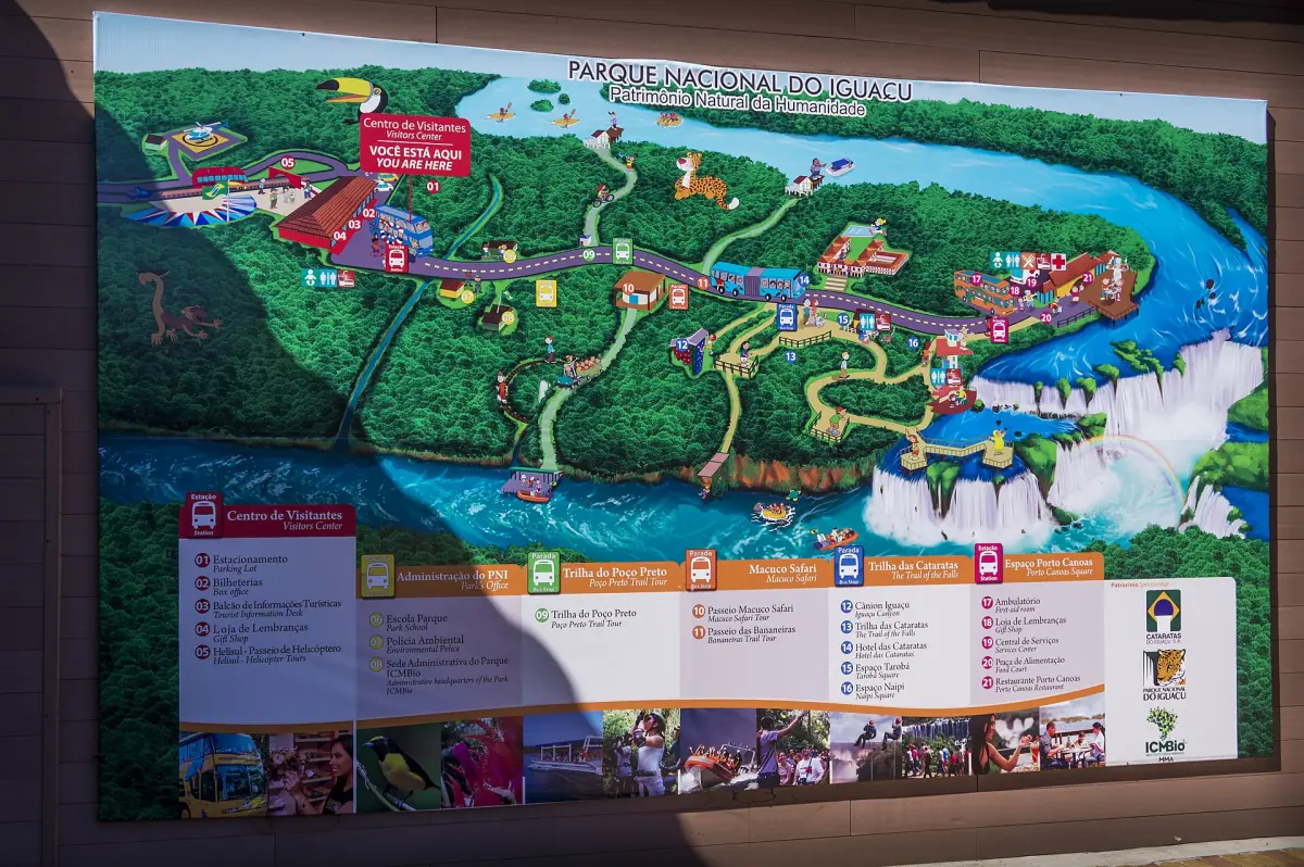
The picture shows the information board of the Brazilian national park, with the falls, the river and the park area. It is a photo of a sign, not a navigation map, so use it to get your bearings and rely on the signs and staff in the park for current routes. Photo: Deni Williams, CC BY 2.0.
Both sides at a glance
Lengths and times as published by the park operators. Status as of October 2026.
| Route | Side | Length | Notes |
|---|---|---|---|
| Upper Trail (Circuito Superior) | Argentina | 1,850 m | Described as fully accessible |
| Lower Trail (Circuito Inferior) | Argentina | 1,450 m | Includes stairs |
| Green Trail (Sendero Verde) | Argentina | 650 m | Described as fully accessible |
| Macuco Trail (Sendero Macuco) | Argentina | 7 km in total | Forest walk, depends on the weather |
| Devil's Throat walkway | Argentina | 2,200 m round trip | Walkways removed in August 2026, no reopening date confirmed |
| Panorama Trail (Trilha das Cataratas) | Brazil | About 1 km on foot | Open in the 13 October 2026 update, while the river walkway was closed |
| Internal transport | Brazil | About 12 km | Visitor center to the panorama trail, included in the ticket |
The Argentine side has several trails and a train. The Brazilian side is a single walk with wide views. Plan each side as its own visit.
Finding your way on the Argentine side
Three train stations and a few trails make up the loop.
Central station
This is the first of the three stops of the Tren Ecológico de la Selva, which is included in the park ticket. Pick up the free train ticket at the points inside the park.
Cataratas station
The middle stop of the train, between Central and Garganta. Use the park signs to find the trails from here.
Garganta station
The last stop, for the Devil's Throat walkway. The walkways were removed in August 2026 as a precaution after higher water, and no reopening date is confirmed. Read the Devil's Throat page for the latest status.
Macuco forest trail
The longest walk is 7 km in total and depends on the weather. Its closing time is earlier than the other trails, about 15:00. Plan it as a separate part of the day.
Iguazu Falls tours and tickets
Day trips from Puerto Iguazú and Foz do Iguaçu, with hotel pickup, border help and boat options.
Finding your way on the Brazilian side
One entrance, one road, one walk.
The entrance
The access is on highway BR 469 at km 18. Private cars do not drive into the park. You park at the entrance for 65 BRL a day (2026, 07:00–19:00) or arrive by bus.
Bus line 120
The line Parque Nacional connects the Foz do Iguaçu bus terminal (TTU), the park and the airport. Check the current timetable before you go.
Inside the park
An internal transport runs about 12 km between the visitor center and the panorama trail. The trail is about 1 km on foot and has elevators, a walkway and the main viewpoints. Some viewpoints were closed in October 2026 because of high water.
Next door
The Parque das Aves bird park is on Avenida das Cataratas at km 17.1, next to the park entrance. It has its own ticket.
Towns, airports and the border
Where to find what around the two parks.
| Place | Country | What it is |
|---|---|---|
| Puerto Iguazú | Argentina | Town with hotels, restaurants and the Hito Tres Fronteras. See Puerto Iguazú |
| Iguazú airport (IGR) | Argentina | Flights from Buenos Aires, on the Argentine side |
| Foz do Iguaçu | Brazil | Larger city, Itaipú and the bird park nearby. See Foz do Iguaçu |
| Foz airport (IGU) | Brazil | About 13 km from the city center, bus line 120 stops at the terminal |
| Tancredo Neves bridge | Border | Crossing between Puerto Iguazú and Foz do Iguaçu |
| Itaipú Dam | Brazil and Paraguay | Large hydroelectric plant. See Itaipú Dam |
To go from one side to the other you cross the border by road. Take your passport and read how to get to Iguazu for entry rules. The two parks are not on the same ticket, so buy each one separately.
Plan the rest of your visit
Use the map with these pages.
Iguazu Falls map: frequently asked questions
Is there one map for both sides?
No. Each park has its own board and its own trails. The picture on this page shows the Brazilian park. On the Argentine side, use the signs at the Central station and the park leaflet.
How far is the Argentine park from Puerto Iguazú?
About 18 km from the bus station, along national routes RN 12 and RN 101. Buses, taxis and transfers cover the trip, and from the airport you can also take a taxi or transfer.
Where is the Brazilian park entrance?
On highway BR 469 at km 18. Private cars stay at the entrance, and an internal transport takes you about 12 km to the panorama trail.
How do I get from the Argentine side to the Brazilian side?
By road over the Tancredo Neves bridge between Puerto Iguazú and Foz do Iguaçu. This is a border crossing, so bring your passport. Check the waiting times on the day.
Can I walk to the Devil's Throat?
The Argentine walkways were removed in August 2026 as a precaution, and no reopening date is confirmed. The other main trails stayed open. Check the current status before you plan a day around it.